
Dutch Forts of Sri Lanka and Where to Find Them
The Dutch forts of Sri Lanka are a unique group of monuments of the island’s tangible cultural heritage. Built by the Dutch East India Company (VOC) in the 17th and 18th centuries during their occupation of the littoral, these forts ranged from large fortified towns and citadels to small forts with a garrison of just 20 soldiers. During the Dutch occupation from 1638 to 1796, they built about 60 forts and numerous other smaller fortifications right around the country with two main concentrations in the west and north of the island. Of these numerous forts, today 11 forts survive as complete monuments and about 9 in varying degrees of remains.
A. Nelson’s The Dutch Forts of Sri Lanka (1984) was the first major work in documenting them, their conservation status, and military analysis and is thus the most well-known study specifically on Dutch fortifications of Sri Lanka. The thesis of Ranjith Jayasena “Om oogh in ‘t zeyl te houden” Historische archeologie van het VOC-grensfort Katuvana in Sri Lanka (2002), and the short paper by Ranjith Jayasena and P. Floore, Dutch Forts of Seventeenth-century Ceylon and Mauritius: An Historical Archaeological Perspective (2010) serve as the next major works in documenting the VOC forts and the formation of a typology and classification based on form and function.
My Master’s thesis (2020) titled “Fortifications and the Landscape: A GIS Inventory and Mapping of Kandyan and Dutch Fortifications in Sri Lanka” from the University of Amsterdam, took the work of Dr. Ranjith Jayasena a step further by building a spatial database through a Geographic Information System (GIS) which involved inventorying and mapping of these forts.
I conducted a deeper historical survey and noted down several more fortification sites not noted by the previous studies and attempted to precisely locate them. It turns out that apart from the well-known sites which survive today, there were many more forts established by the Dutch, and since much of these sites existed for only a short period of time (generally during times of war), their exact locations have been lost and are probably known only locally.
This rather extensive article serves to disseminate this knowledge to a general audience; discussing the nature of the forts, i.e., their architecture and function and their locations.
Architecture
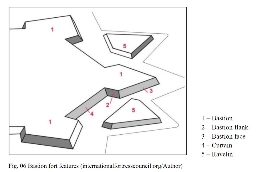
First, a brief look at the architecture of the Dutch forts. European military architecture saw a revolution with the introduction of gunpowder weaponry in the 15th century. This was pioneered by Italian engineers in the late-15th century and the key element in this new design was the bastion.[1] From the 16th century onwards military architecture became a complex field of engineering in Europe with several ‘schools’ such as the Italian, Dutch and French.[2]
The resultant fort of this revolution mentioned above was commonly called the bastion fort, for the fact that the feature known as the bastion played an important role in the function of the fort. The bastion was designed in a geometric fashion with angles so that every point outside the fort could be covered by the guns of the fort. The bastion thus acted in a defensive function by covering the sides of the fort and as an offensive function by forming a battery that could counter enemy fire. The bastions were placed at the corners of the fort and joined by a curtain that formed the rampart. The fort was further protected by a moat which could be a dry or wet moat, and other outer features such as the ravelin, glacis, and hornwork.
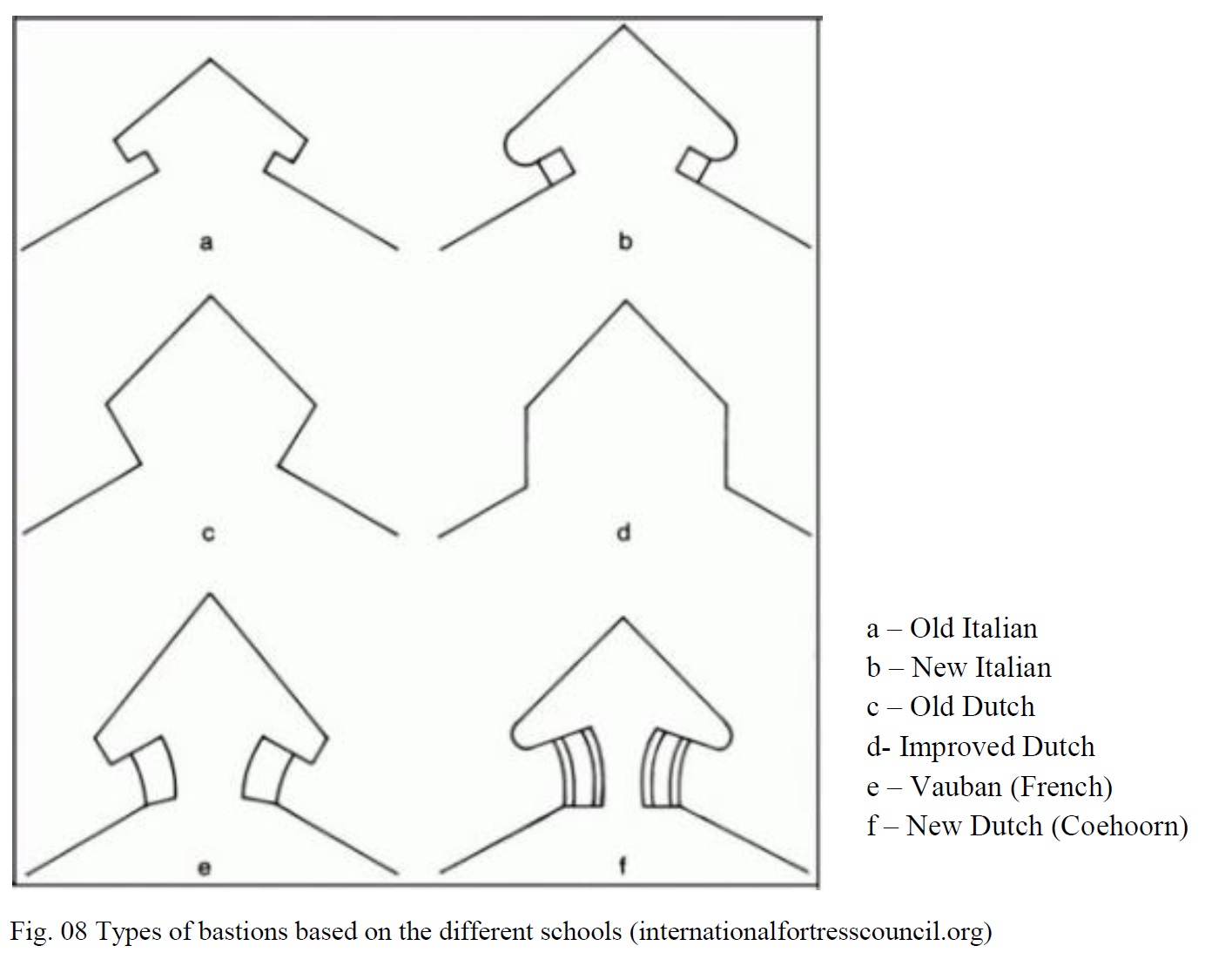
The Italian system of fortification was commonly known as the trace italienne and was soon adopted by the Portuguese in their colonies during the 16th century. As such the Portuguese were the first to introduce the European system of fortification to Sri Lanka. The Dutch school of fortifications was further divided into the Old Dutch system or Oudnederlands Stelsel, the Improved Dutch and the New Dutch system, the latter was also known as the Coehoorn system after the pioneer engineer in the early 18th century. Figure 08. gives a simple overview of the three main schools of European fortress architecture and their variants.
The Old Dutch system was the first of the system of fortifications introduced to the colonies in the 17th century and is almost the exclusive type of fortress architecture of the Dutch forts of Sri Lanka. When the Dutch took over the Portuguese forts between 1638 and 1658, they most often rebuilt (sometimes integrating sections into their works) the Portuguese forts into their architecture as the former represented older designs of the trace italienne (see figure 08).
The VOC and their forts in Sri Lanka
Although the Dutch first arrived in Sri Lanka in 1602, it was only in 1638 that they entered into a treaty with the king of Kandy, which gave them a foothold in the island. In the initial years between 1638 and 1658 during the war with the Portuguese, they most often reused the Portuguese forts which were captured. However by the end of the 1650s they had begun to rebuilt the forts which they already occupied at that time according to their architectural standards. A characteristic of the Dutchman was his acute attention to planning and design, which is still seen in the Netherlands today. Therefore every fort and its internal layout was carefully planned out by qualified military engineers and surveyors.
The late 1650s and early 1660s were spent on consolidating their hold in the territories they occupied. This was primarily done through the redevelopment of the forts, some on the old Portuguese sites and some on new sites. Then the uneasy peace that existed between the Dutch and the kingdom of Kandy from the late 1650s came to an end when a rebellion broke out in the kingdom in 1664. King Rajasinghe requested the Dutch for assistance and one thing led to another and resulted in what could be aptly called the first Kandy-Dutch war between 1665 to 1675. (For full detail on this war see the link http://thehistoryfreek.blogspot.com/2021/04/first-kandy-dutch-war-1665-1675.html). This war saw an inland expansion of the Dutch territories which resulted in a large number of fortifications being built; the largest number of forts established during their entire period of occupation. However by the end of the 1600s the war was over and their governing policy and relations with Kandy had changed completely; therefore while all fortifications established during the war in Kandyan territory were abandoned, they even abandoned some posts within their own recognized territories.
Once again during the second Kandy-Dutch war between 1761 to 1766 (For full detail on this war see the link http://thehistoryfreek.blogspot.com/2021/04/second-kandy-dutch-war-1761-1766.html), they established more fortifications, some being at sites used and abandoned during the previous war. However towards the end of that century most forts were badly manned and soon fell to British hands, with only Trincomalee putting up a defence. Even the most well planned fort in the island, Jaffna, was abandoned in the face of the approaching British force.
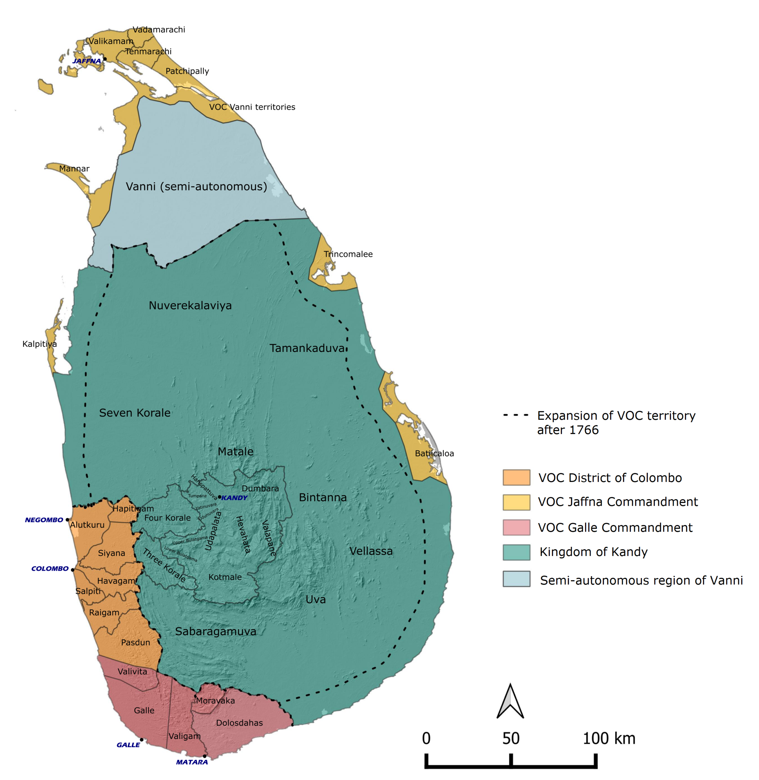
The political landscape of Sri Lanka in the early 18th century (Mendis, 2020)
Nature of the forts
For the Dutch like the Portuguese, the fort was everything. It functioned as a base of operations not only for military activities but for economic activities and administration as well. Such fortifications, whatever the size, were always located at strategic points, whether along the coast near ports or inland along main roads and rivers. The size of the forts depended on their function and not necessarily on their location, although in general, the larger forts are found along the coast near ports. The larger ones like Colombo and Galle were over 100,000 square meters while the smaller ones such as Arippu were around 450 square meters. Apart from what could be easily identified as a fort, there was another kind of fortification, one of more temporary nature and smaller than the smallest stone fort. Such sites mainly occur during times of war (during the two main wars with the kingdom of Kandy) and are variously termed such as guard-posts, out-posts, watch-posts, watch-houses, and stations. They tend to function for lines of communication (transport of letters), for garrisons of the local militia (Lascorins), for military campaign-related posts and campsites, or even as active defense works. Their form is not described, however, based on their smaller function, it could be interpreted that they were either a single building with some measure of defense or simple stockades.
The forts were designed to give complete protection to the Dutch establishment on the island, where they could function as part of a network of fortifications or as an independent unit. The enemies the Dutch kept in mind when designing the forts were the Kandyans and other European nations such as the English, French, and Danish. It could be also argued that based on the complexness of the larger defense works, the Dutch were mostly concerned with other Europeans rather than the local kingdom, whom they knew had not have the resources to siege such forts. Establishing forts also had another subtle function, apart from military, economic, and administrative functions; they were used to project ownership and authority of the lands.
When constructing the forts, the choice of primary material was generally selected on the availability of appropriate material in the area. While the core of the rampart was earth (dugout when cutting the moat), it was covered in a layer of solid material, which in Sri Lanka ranged from stone, coral, and kabook (laterite). Therefore the forts generally in the western coast were built of kabook, the northern ones out of coral and the southern ones out of stone. This however concerns only the larger forts or the ones used for a longer period. There were smaller forts built along the interior roads which were most often built of temporary material.
For a short case study description of the three forts of Colombo, Mannar, and Katuwana, follow the link http://thehistoryfreek.blogspot.com/2021/04/short-descriptions-dutch-forts-of.html
For short eye-witness accounts and other interesting snippets of the selected fortification sites of Anguruwatota, Arandara, Arippu, Arugambay, Bibilegama, Chilaw, Chundikulam, Gonavila, Iluppaikkadavai, Kananvila, Malwana, Puttalam, and Ratnapura, follow the link http://thehistoryfreek.blogspot.com/2021/04/short-insights-into-some-selected-dutch.html
The above is an attempt to give a brief overview of the nature of the forts built by the Dutch in Sri Lanka. A fort is a machine, with its fortifications being only one component of the machine. The garrison – the soldiers, the cannon, the armory, etc. all form part of the machine that is the fort. Explaining these components is however left for another time.
Given below is a scientific classification of the form and function of the forts and also a chronological timeline. These are given here for the more curious reader. The list of sites and maps would follow this section.
Form and Function and classifications
Dr. Ranjith Jayasena is the first to systematically classify the fortifications of the Dutch in Sri Lanka. He puts forward a classification of the Dutch military posts in their functional and morphological aspects. In my thesis, I added one more classification type each for function and form.
Main Forts
Main forts – 1
As major administrative, military and economic centers
Main forts – 2
At strategic locations to safeguard the monopoly on trade goods
Main forts – 3
As centers of storage of trade goods
Secondary Forts
Secondary forts – 1
To safeguard the trade monopoly and for the collection of the trade goods
Secondary forts – 2
Primarily to defend the VOC territory
Secondary forts – 3
Primarily to defend the VOC territory with the capacity for storage
Non-permanent watch-posts
Defense works that cannot be classified as forts but which were military in nature in overall defense and control of the landscape.
Table. 01 Dutch forts classification based on function according to Jayasena (2010); last type according to Mendis (2020).
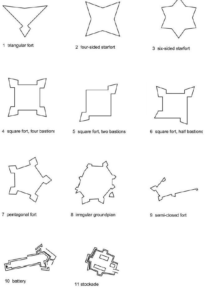
Type 01
Three-sided fort
Type 02
Four-sided star fort
Type 03
Six-sided star fort
Type 04
Square fort with four bastions
Type 05
Square fort with two diagonally opposite bastions
Type 06
Square fort, a variant with half bastions
Type 07
Five-sided fort
Type 08
More-sided fort with a regular or irregular ground plan
Type 09
Bastioned front, semi-closed fort
Type 10
Battery (permanent)
Type 11
Stockade (pagger), an earthwork with an irregular ground plan
Type 12
Single building or stockade smaller than or less explicit to Type 11.
Table. 02 Dutch forts morphological classification according to Jayasena (2010); last type according to Mendis (2020).
Typology of Dutch forts of Sri Lanka (Jayasena, 2010)
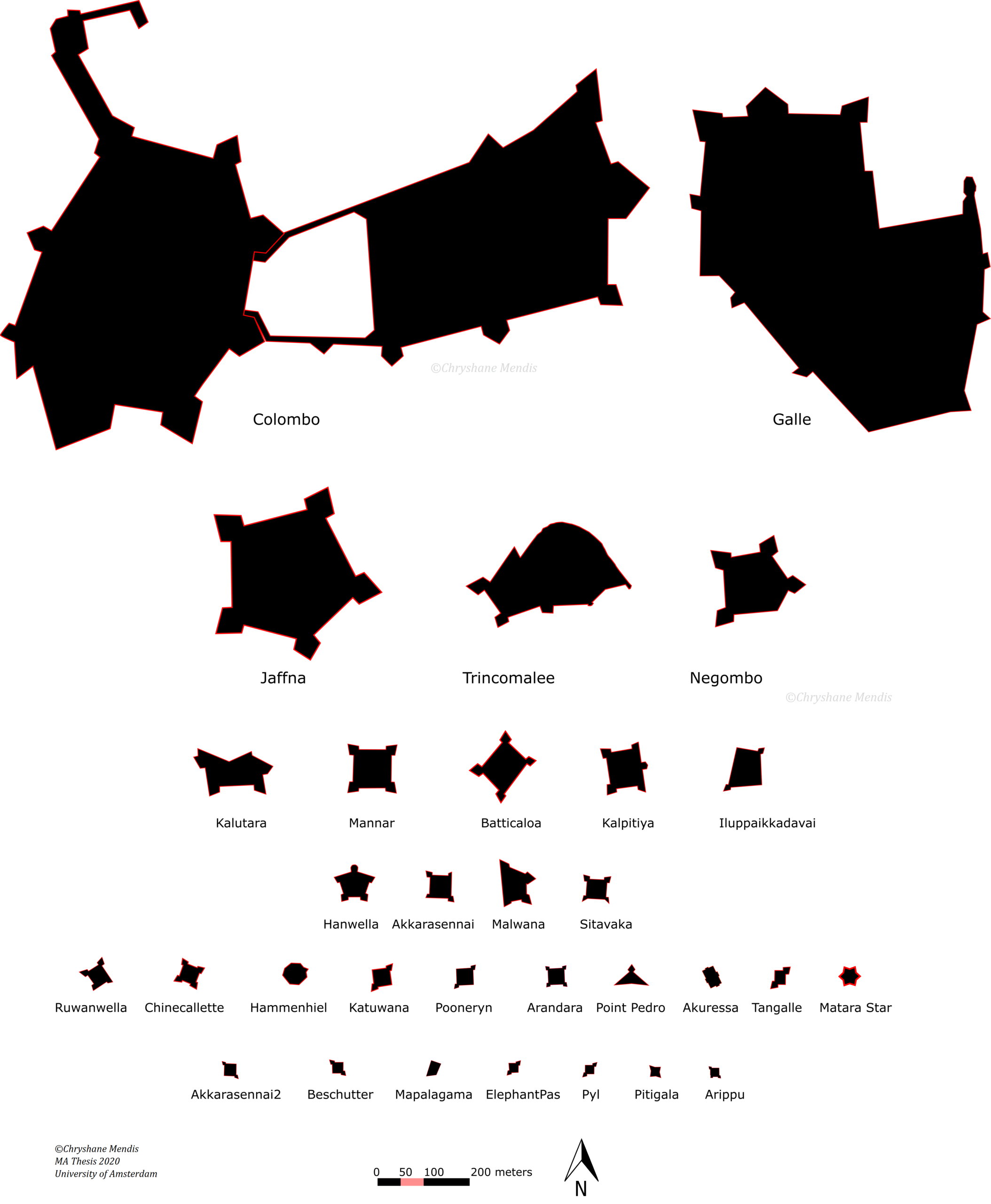
Comparison of Dutch Forts of Sri Lanka (Mendis, 2020).
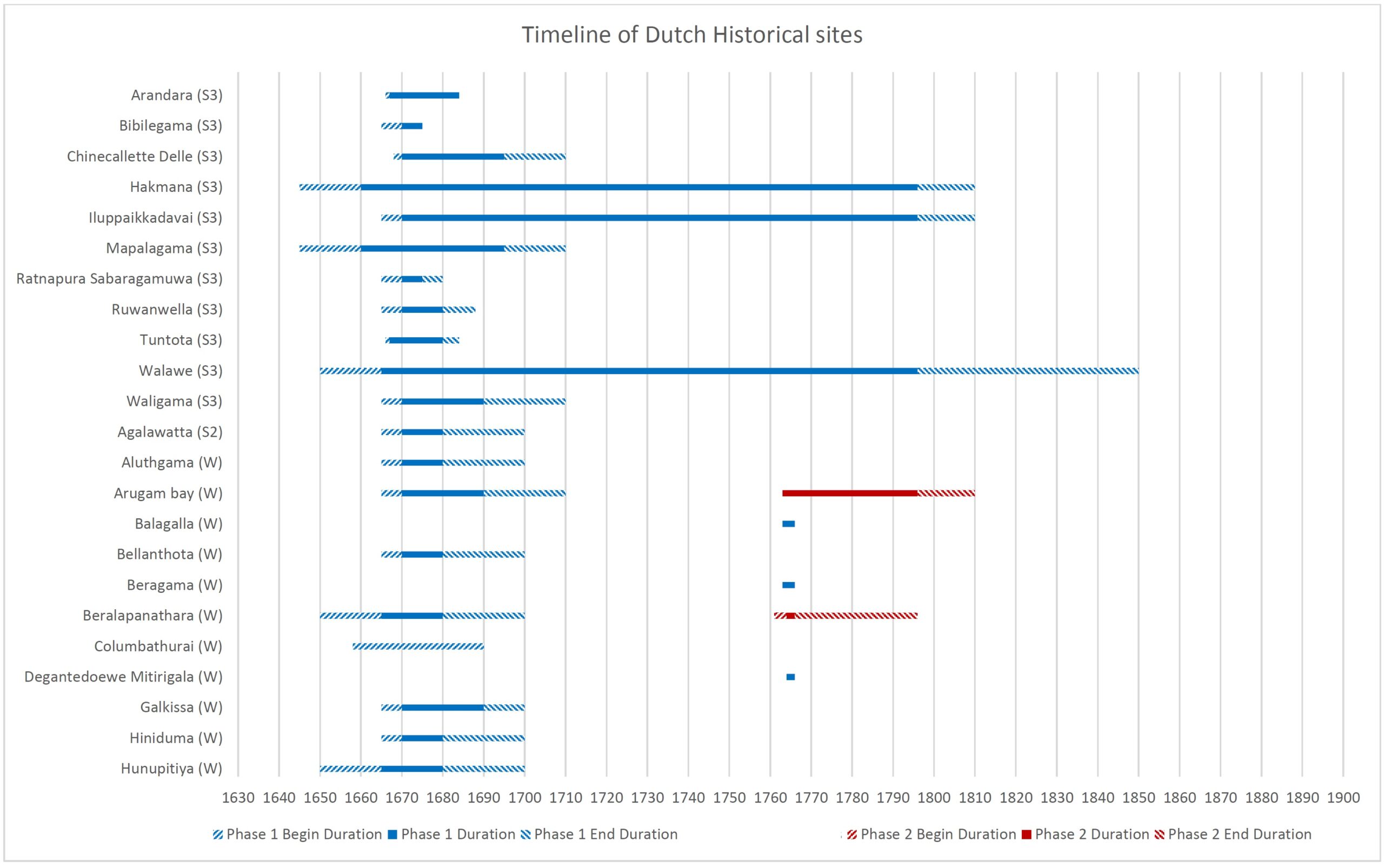
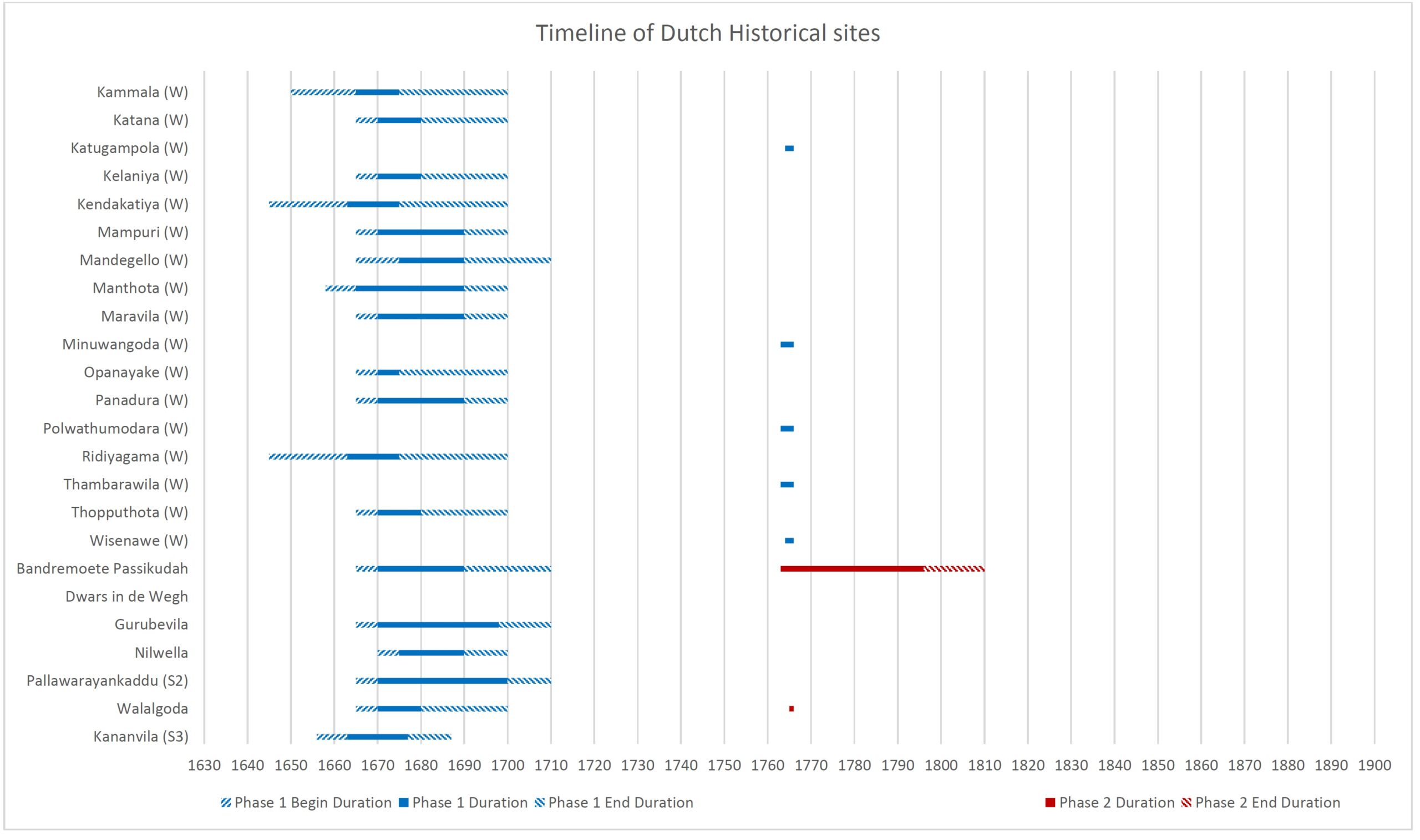
Timeline of sites
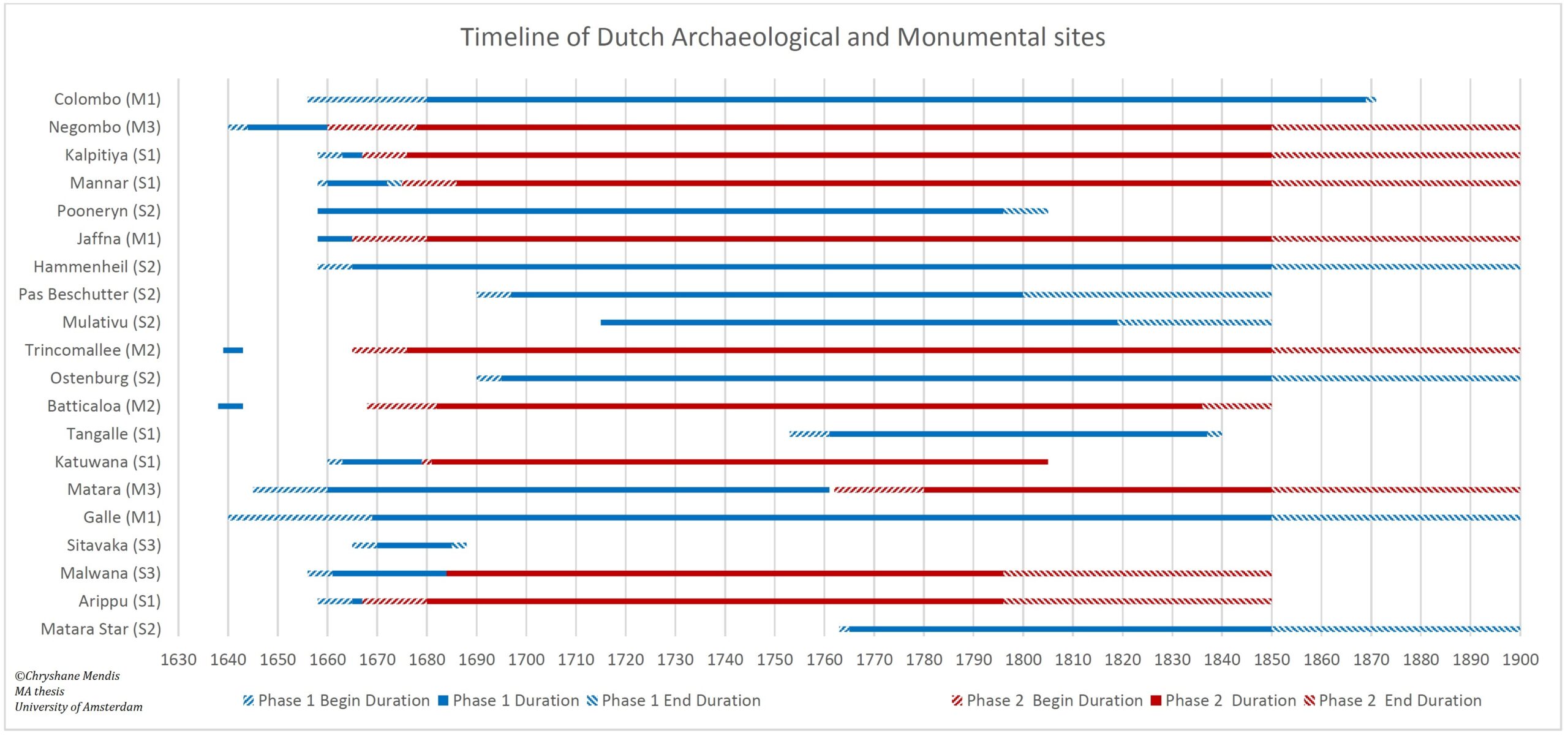
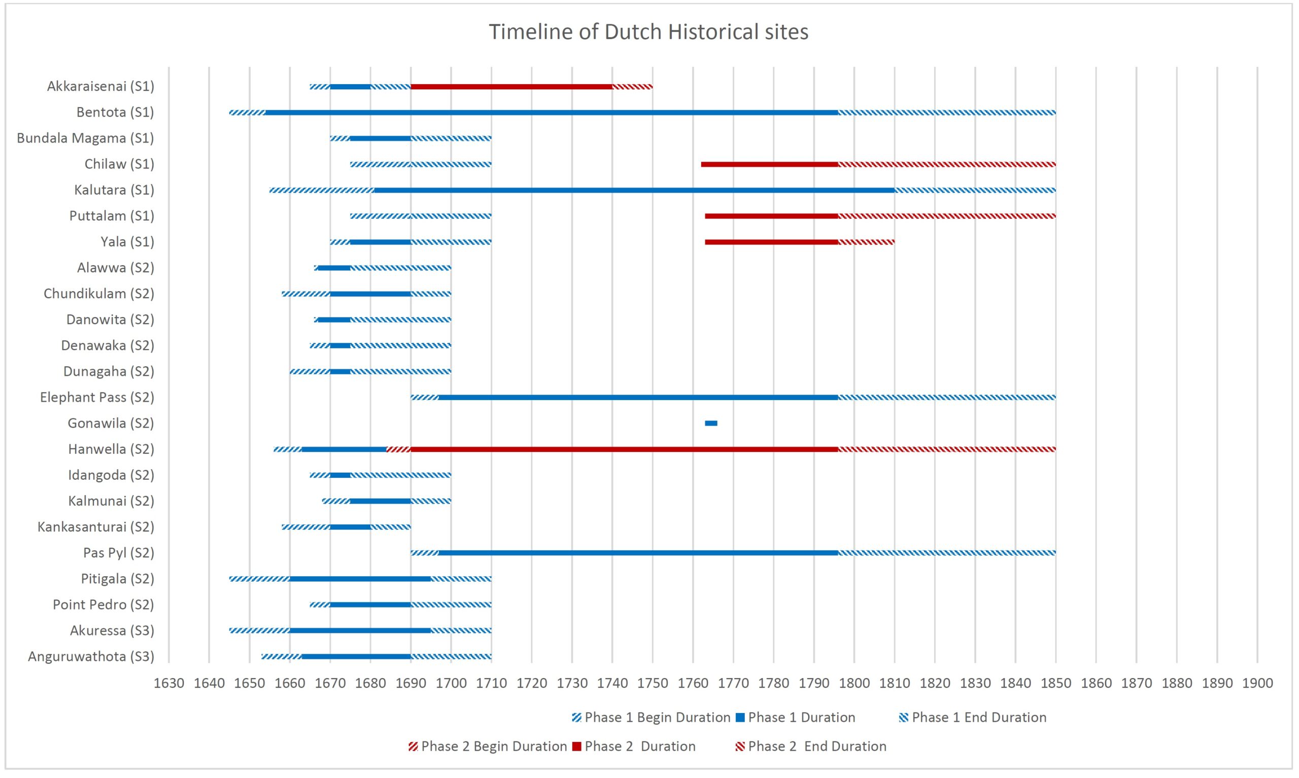
In my study, I defined the historical chronology as the beginning and end of use of the site for its intended function – as a fortification. ‘Beginning’ here signifies the construction of the fort while ‘End’ signifies the abandonment, demolition or the end of its use as a fortification.
Obtaining exact dates was difficult and further in almost all cases of larger forts, they were constructed over several years or even decades. Hence a range of years was necessary to depict a site’s chronology. To this effect, a schema of earliest and latest dates was taken for the beginning and for the end.
Beginning
Earliest date
Latest date
End
Earliest date
Latest date
Further, based on the historical survey of the fortifications, it was found that certain sites had the second phase of construction which was distinguishable from the first instance by form or chronology. Therefore the phases are distinguished as a) complete changes to the form in a continuous period (such as Katuvana from a stockade to the stone fort; Mannar from one form to the present form; Jaffna from the usage of Portuguese fort for a few years and reconstruction of new work), and b) abandonment and reoccupation after a long period of time/long interval – several decades. Modifications to the existing form were not taken as a separate phase (e.g Jaffna’s outer works from 1765-1792).
As the below graphical timeline would show, the forts were not static; that not all sites were begun, occupied, and ended at the same time. Some existed for a short period while others lasted longer, some had a second phase in a continuous period while other second phases occurred after a long interval. This temporal dimension can often be distorted in maps as it would only give a spatial overview.
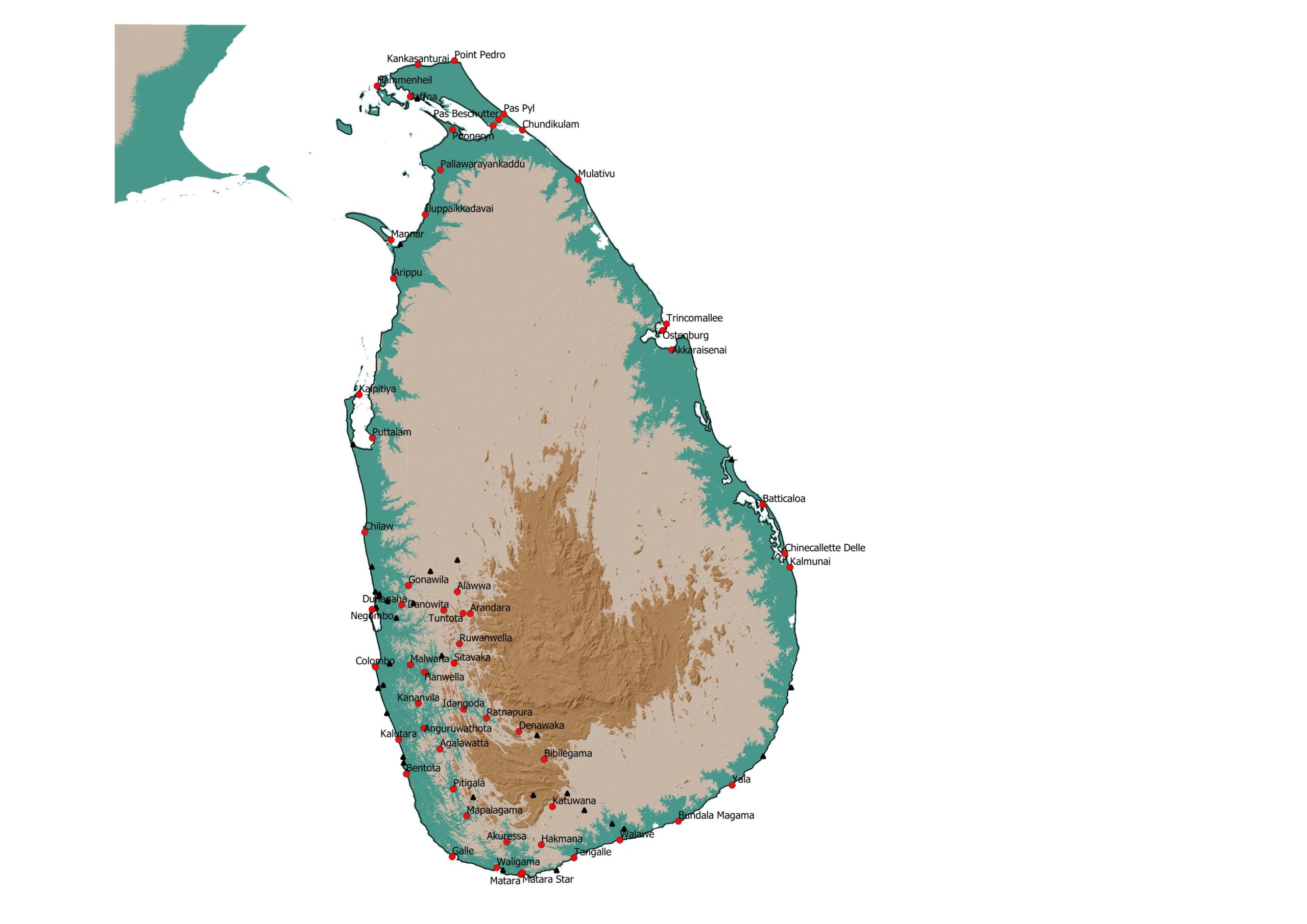
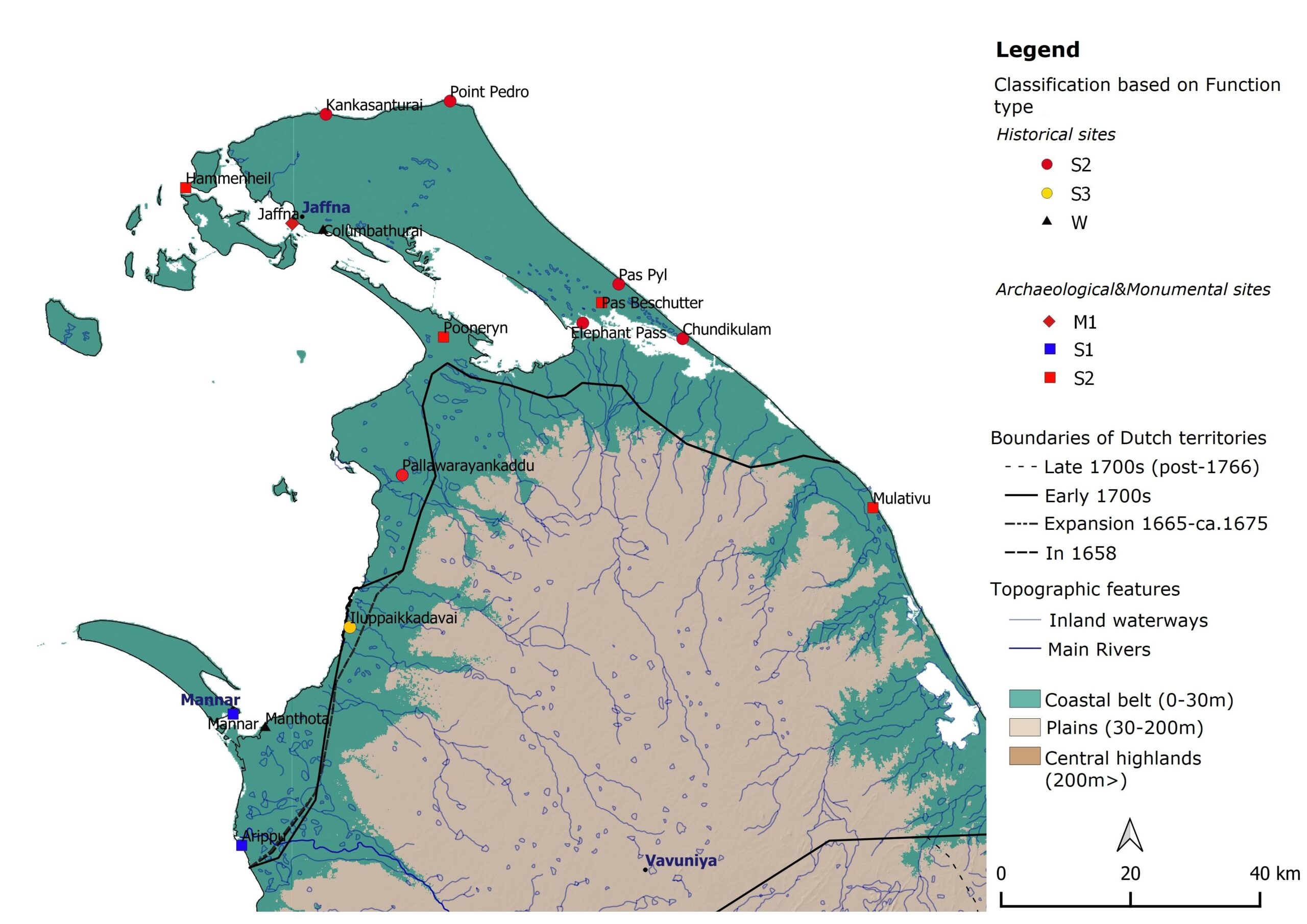
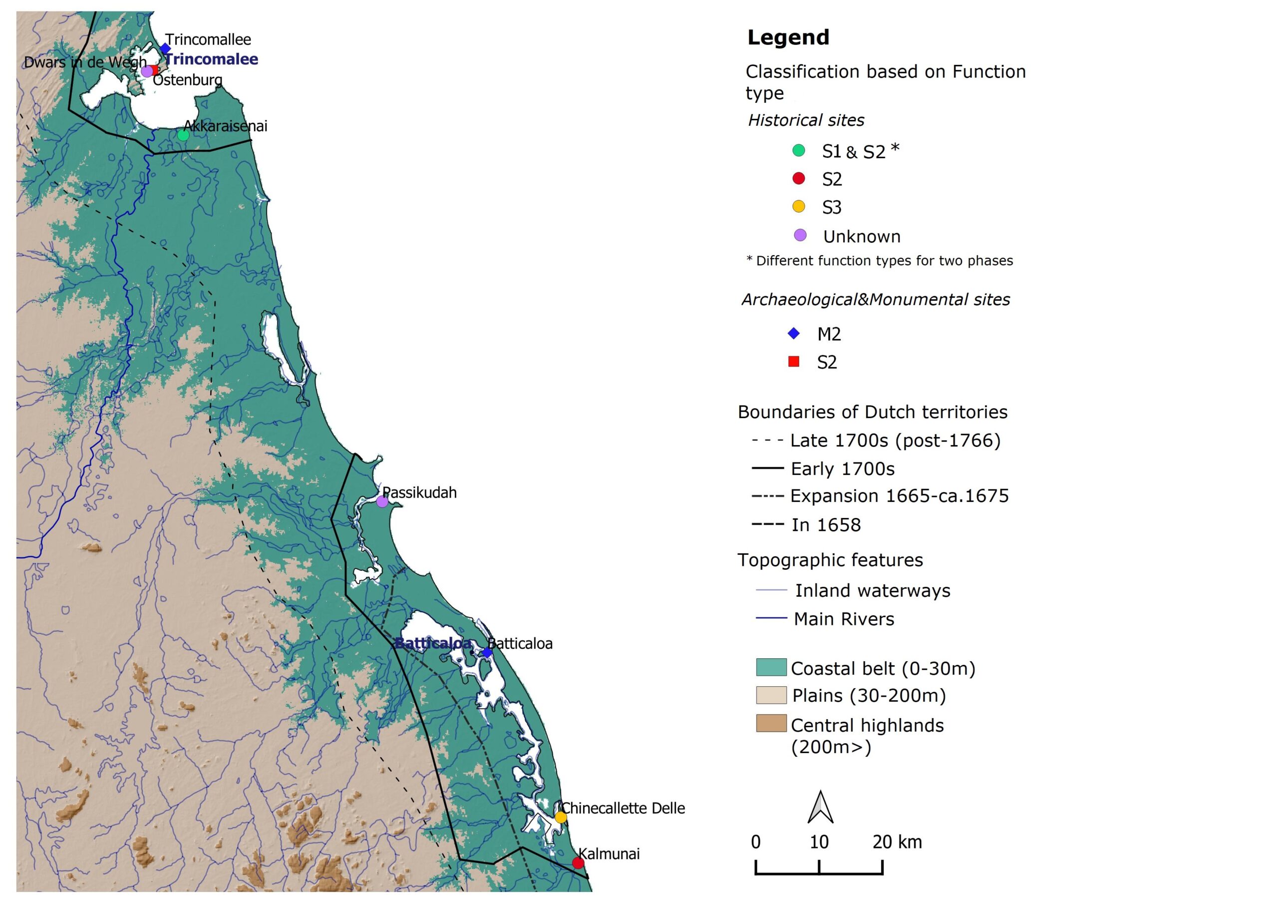
Distribution of the Dutch fortifications of Sri Lanka. Red are the sites categorized as forts (classified above as Main and Secondary forts), Black triangles are the Non-permanent watch-posts.
Monumental and Archaeological sites
Through my thesis, I was able to identify twenty sites with remains at present. Eleven are complete monuments while nine are less complete (partial remains of internal structures, foundations, ramparts or gateways, etc).
Monumental sites
Name
Function type
Form type
Historical territory
Present District
1
Galle
M1
8
Galle Kōralē
Galle
2
Jaffna
M1
7
Valikamam
Jaffna
3
Trincomalee
M2
9
Trincomalee
Trincomalee
4
Batticaloa
M2
4
Batticaloa
Batticaloa
5
Mātara
M3
9
Dolosdahas Kōralē
Mātara
6
Tangalle
S1
5
Dolosdahas Kōralē
Hambantota
7
Kalpitiya
S1
6
Kalpitiya
Puttalam
8
Mannar
S1
4
Mannar
Mannar
9
Mātara star
S2
3
Weligam Kōralē
Mātara
10
Hammenheil
S2
8
Jaffna
11
Katuvana
S3
5
Dolosdahas Kōralē
Hambantota
Sites with varying degrees of archaeological remains.
Name
Function type
Form type
Historical territory
Present District
1
Colombo
M1
8
Salpiti Kōralē
Colombo
2
Negombo
M3
7
Aluthkuru Kōralē
Gampaha
3
Arippu
S1
5
Mannar
Mannar
4
Pooneryn
S2
5
Kilinochchi
5
Pas Beschutter
S2
5
Patchipally
Kilinochchi
6
Trincomalee Ostenburg
S2
10
Trincomalee
Trincomalee
7
Mulativu
S2
Mullaitivu
8
Malvāna
S3
6
Siyana Kōralē
Gampaha
9
Sitāvaka
S3
4
Three Kōralēs
Kegalle
Timeline of Dutch Archaeological and Monumental Sites
Historical sites
These are the sites documented in my thesis which lack any archaeological remains as per the data available to me during the time of writing. However, field surveys of these sites may still reveal surface features. Since the publication of my thesis, I was informed that the foundations of the Kalutara fort may still be there, even the foundations of the Hakmana fort. Therefore ground-truthing for such sites may reveal more traces.
These historical sites are further separated into the secondary forts and non-permanent watch posts (W) as classified above.
Historical Secondary forts
Name
Function type
Form type
Historical territory
Present District
1
Agalavatta
S2
12
Pasdun Kōralē
Kalutara
2
Akkaraisenai
S1,S2
6,5
Trincomalee
Trincomalee
3
Akurässa
S3
11
Weligam Kōralē
Mātara
4
Alauva
S2
11
Kurunegala
5
Anguruvatota
S3
11
Raigam Kōralē
Kalutara
6
Arandara
S3
4
Four Kōralē
Kegalle
7
Bentota
S1
11
Weliwita Kōralē
Galle
8
Bibilēgama
S3
–
Ratnapura
9
Būndala Māgama
S1
11
Hambantota
10
Chilaw
S1,S1
–
Seven Kōralē
Puttalam
11
Chinecallette Delle
S3
4
Batticaloa
Batticaloa
12
Chundikulam
S2
–
Patchipally
Jaffna
13
Danōvita
S2
11
Hapitigam Korlale
Gampaha
14
Denavaka
S2
11
Ratnapura
15
Dunagaha
S2
11
Aluthkuru Kōralē
Gampaha
16
Elephant Pass
S2
5
Patchipally
Kilinochchi
17
Gōnavila
S2
11
Seven Kōralē
Kurunegala
18
Hakmana
S3
11
Dolosdahas Kōralē
Mātara
19
Hanvälla
S2,S3
11,7
Hewagam Kōralē
Colombo
20
Idangoda
S2
11
Ratnapura
21
Iluppaikkadavai
S3
5
Mannar
22
Kalmunai
S2
11
Batticaloa
Ampara
23
Kalutara
S1
8
Pasdun Kōralē
Kalutara
24
Kananvila
S3
4
Raigam Kōralē
Kalutara
25
Kankasanturai
S2
–
Valikamam
Jaffna
26
Mapalagama
S3
11
Galle Kōralē
Galle
27
Pallavarayankaddu
S2
–
Kilinochchi
28
Pas Pyl
S2
5
Patchipally
Jaffna
29
Pitigala
S2
2
Weliwita Kōralē
Galle
30
Point Pedro
S2
1
Vadamarachi
Jaffna
31
Puttalam
S1,S1
-,4
Seven Kōralē
Puttalam
32
Ratnapura
S3
5
Ratnapura
33
Ruvanvälla
S3
6
Three Kōralē
Kegalle
34
Tuntota
S3
6
Four Kōralē
Kegalle
35
Valavē
S3
11
Dolosdahas Kōralē
Hambantota
36
Väligama
S3
–
Weligam Kōralē
Mātara
37
Yāla
S1
–
Hambantota
Historical Non-permanent watch posts
Name
Function type
Form type
Historical territory
Present District
1
Alutgama
W
12
Weliwita Kōralē
Kalutara
2
Arugam bay
W
–
Ampara
3
Balagalla
W
–
Aluthkuru Kōralē
Gampaha
4
Bellantota
W
12
Salpiti Kōralē
Colombo
5
Beragama
W
–
Hambantota
6
Beralapanatara
W,W
12,12
Morawak Kōralē
Mātara
7
Columbaturai
W
12
Valikamam
Jaffna
8
Mitirigala
W
–
Siyana Kōralē
Gampaha
9
Galkissa
W
12
Salpiti Kōralē
Colombo
10
Hiniduma
W
12
Galle Kōralē
Galle
11
Hunupitiya
W
12
Aluthkuru Kōralē
Gampaha
12
Kammala
W
12
Seven Kōralē
Puttalam
13
Katāna
W
12
Aluthkuru Kōralē
Gampaha
14
Katugampola
W
–
Seven Kōralē
Kurunegala
15
Kälaniya
W
12
Siyana Kōralē
Gampaha
16
Kendakatiya
W
12
Dolosdahas Kōralē
Hambantota
17
Māmpuri
W
12
Kalpitiya
Puttalam
18
Mandegello
W
–
Hambantota
19
Māntota
W
12
Mannar
Mannar
20
Māravila
W
12
Seven Kōralē
Puttalam
21
Minuvangoda
W
–
Aluthkuru Kōralē
Gampaha
22
Opanāyaka
W
12
Ratnapura
23
Pānadura
W
12
Raigam Kōralē
Kalutara
24
Polvatumōdara
W
–
Weligam Kōralē
Mātara
25
Ridiyāgama
W
12
Hambantota
26
Tambaravila
W
–
Seven Kōralē
Puttalam
27
Topputota
W
12
Seven Kōralē
Puttalam
28
Visenāva
W
–
Seven Kōralē
Kurunegala
29
Pāssikudah
–
–
Batticaloa
Batticaloa
30
Dwars in de Wegh
–
–
Trincomalee
Trincomalee
31
Gurubevila
–
11
Hewagam Kōralē
Colombo
32
Nilvella
–
–
Dolosdahas Kōralē
Mātara
33
Valalgoda
–
–
Ratnapura
34
Beruwala
35
Maggona
Timeline of Dutch Historical Sites
Timeline of Dutch Historical Sites
Timeline of Dutch Historical Sites
Distribution of all inventoried Dutch fortification sites – North central and Northern Sri Lanka (Mendis, 2020)
Distribution of all inventoried Dutch fortification sites – Eastern Sri Lanka (Mendis, 2020)
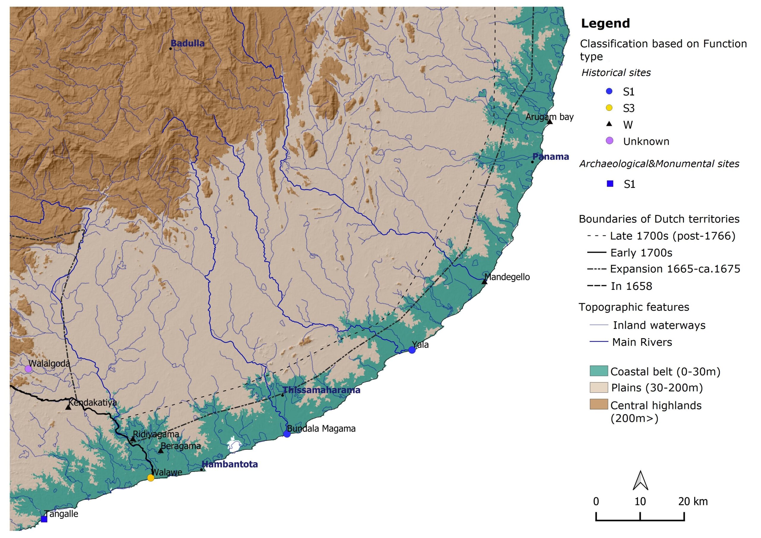
Distribution of all inventoried Dutch fortification sites – South eastern Sri Lanka (Mendis, 2020)
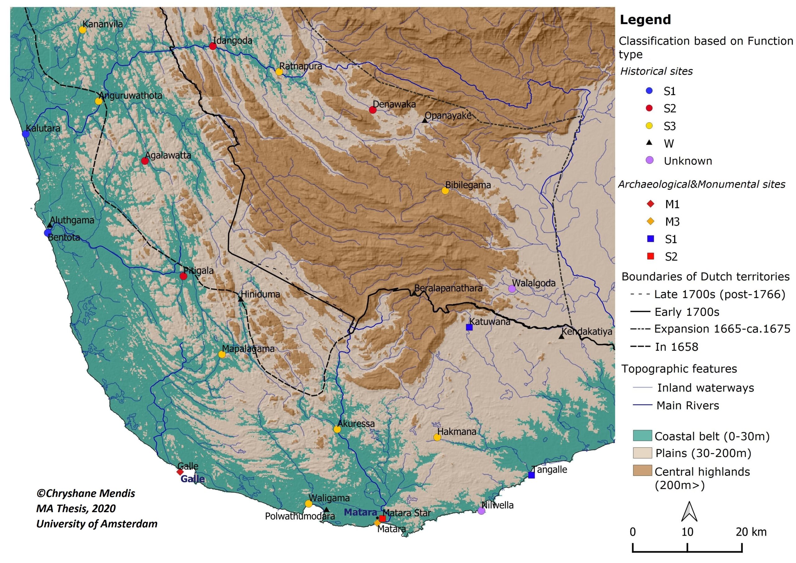
Distribution of all inventoried Dutch fortification sites – Southwestern and Southern Sri Lanka (Mendis, 2020)
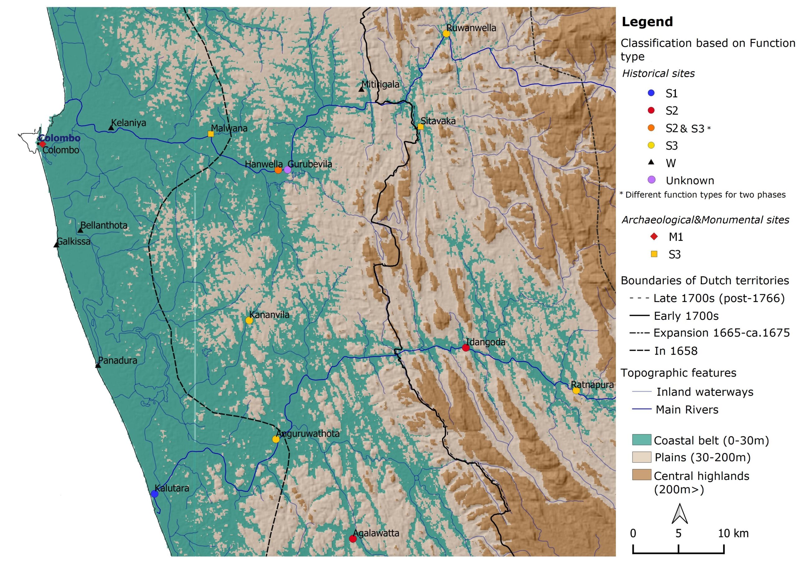
Distribution of all inventoried Dutch fortification sites – Western Sri Lanka around Kelani Ganga and Kalu Ganga river basins (Mendis, 2020)
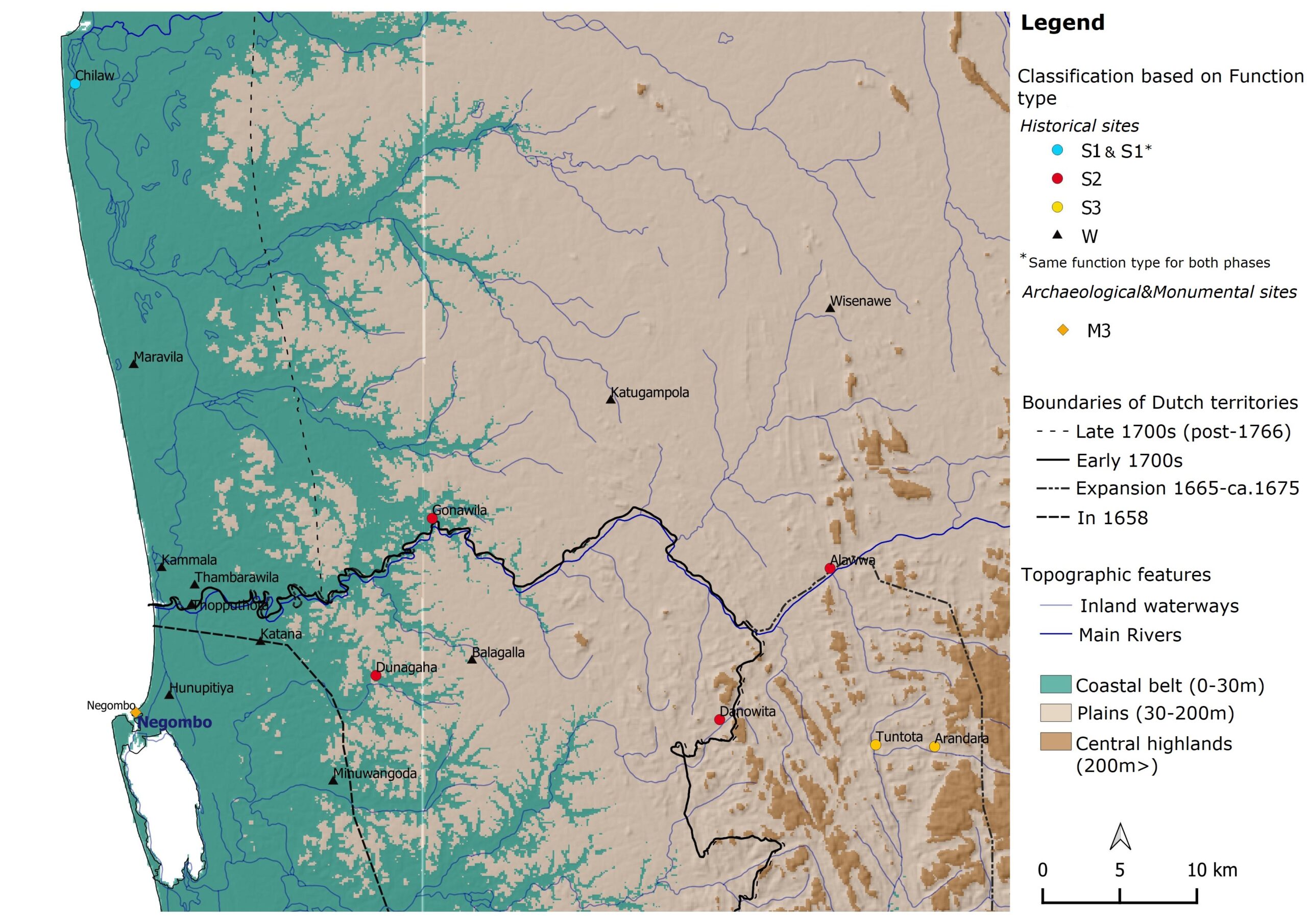
Distribution of all inventoried Dutch fortification sites – Western Sri Lanka around Maha Oya basin (Mendis, 2020)
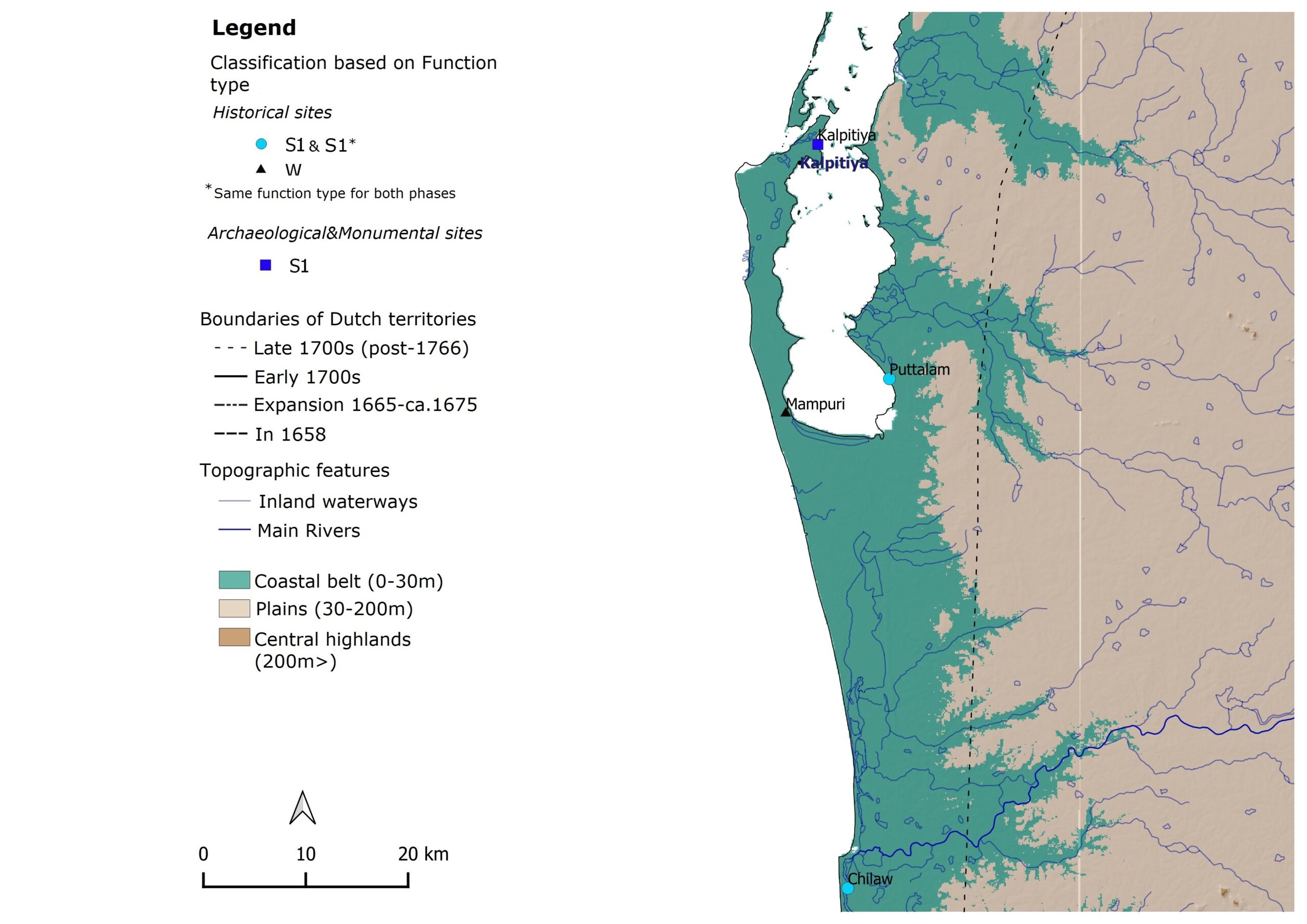
Distribution of all inventoried Dutch fortification sites – Western Sri Lanka around the Peninsula of Kalpitiya (Mendis, 2020)
[1] Jayasena, R. & Floore, P., 2010. Dutch forts of seventeenth-century Ceylon and Mauritius: An historical archaeological perspective. p.237
[2] Hughes, J. Q., 1974. Military architecture, p.102,134, 138